Description


ABGPS
• adds your GPS location to your Contacts cards.
• opens your favorite navigation app* directly from the device address book.

ABGPS is available in free version and pro version **

More generally, ABGPS allows all uses GPS coordinates in collaboration with the functions of your iPhone that allows you to accurately find your parking spot or Jack ski chalet…

  1. obtaining the current position (or input known coordinates), now possible from the Apple Watch**
  2. obtaining the postal address from the GPS coordinates (requires Internet connection)
  3. save GPS coordinates in Contacts**, the address book of the device, and sync via iCloud
  4. saving and sharing links with ABGPS, Google Maps and Apple Maps
  5. sending coordinates to a navigation application* from the app or directly from Contacts**
  6. simplified backup of a temporary GPS point** (a parking space for example) and navigate to it
  7. sharing by sms, email, …

Apple Maps, Google Maps, Mappy GPS, MAPS.ME, MotionX-GPS, Navigon, Navmii, Sygic, TomTom, Waze.

** Limitations of the free version (Pro version available via in-app purchase):
• saving GPS coordinates in Contacts limited to 5
• fast management of temporary GPS points unavailable (the points acquired from the Apple Watch are therefore unusable)
• opening an abgps:// link from a third party app (including Contacts app) not available

Help


In case of difficulty:
please read the help page (only in French for now)
read the frequently asked questions (FAQs) below
make a support request

FAQ


What are the compatible devices?

Compatible devices

All iPhone, iPod and iPad with iOS 9.0 minimum are compatible.

Limitations

IPod and iPad Wifi (without GSM option) do not have a GPS chip.
The accuracy of your location will be affected.
More information on the Apple website: About privacy and Location Services

In addition, the display is not optimized for iPad.

How to open ABGPS from an HTML link or other iOS app?

You can find information on the URL scheme on the site handleOpenURL

How to use geolocation for efficient navigation?

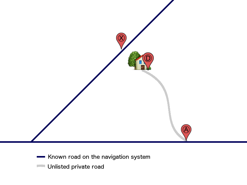
Be aware that the navigation systems that guide validly on listed roads only. Besides the ways directory may be incomplete, it contains no private roads, not even their point of attachment to the known road network.

In a situation with access by an unknown route of the navigation system, it may be necessary to make two statements:
1- The last known point of the navigation system (usually the access point of the private road on a known route);
2- Real destination point Ⓓ.
The points are recorded in the same contact card (differentiate labels: Access forand Destination for example).

Without this precaution the navigation system can guide you to a remote place and without a real access solution .